Wednesday, April 26, 2023

Research: About a Trip to Sicily (1)

My Father Spent Three Months in the Mediterranean, 1943

I Will Visit 80 Yrs Later, to Recall Operations Husky & Baytown

D. Harrison stole chickens from a Sicilian cook in 1943, near Messina
When I fly over, I will pay back his debt! ("How much are 6 chickens?")

Introduction:

As a member of RCNVR and Combined Operations (1941 - 1945) my father drove Landing Craft Mechanised (LCMs) during Operation Husky (Allied invasion of Sicily) - beginning July 10, 1943 - and Operation Baytown (Allied invasion of Italy at the toe of the boot) - beginning September 3, 1943. [His memoirs re those Allied invasions can be found on this site.]

In a few months I will travel to Sicily and the toe of Italy's boot to walk in his faint footsteps, see some of the very same beaches, the lovely horizon of the Med, Sicilian towns and cities, visit (hopefully) the same cave he lived in for 3 weeks during Operation Husky (if I can find it; I think I can!), and buy a few chickens to pay off a long-standing debt (i.e., 80 years old!).

When I go I'll do what I did while in Scotland, England, Halifax and Vancouver Island a few years ago. Meet a few people who share an interest in WWII history, visit RCNVR and Combined Operations sites (related to training or service), hit a pub or two that my father hit many years earlier, "paint the town brown" (his words), check out related museums, libraries, archives, and be thankful I can travel to such places and meet such people.

In Sicily I will travel to Avola (south of Syracuse SE corner) for certain. The city is close to the area that four 'Flotillas of Canadian Landing Crafts' transported British troops and all the materials of war to beachheads in support of those troops. The following maps will help me find my way:

Map re Allied landings as found in Combined Operations (a book re
the role of Canadians in Combined Ops) by Clayton Marks, London

Members of RCNVR/Comb.Ops like my father worked aboard landing
crafts on the east coast between Syracuse and Cape Passero. (Canadian
Army troops landed in southern Sicily, west of Cape Passero)

The map above puts my father, a member of the 80th Flotilla, somewhere near Avola. He mentioned the town or city in his memoirs but never mentioned the sector or beaches where he worked/served for four weeks.

Some of the members of the 80th Flotilla are listed upon a navy hammock.
Painter - S/Lt. Dave Rodgers. Hammock - W. N. Katanna, Leading Stoker.
Hammock as found at Navy Museum, HMCS Naden, Esquimalt B.C.

Though Dad never mentioned his location or sector (where delivery/unloading of supplies would take place) near Avola, his commanding officer provides important details in memoirs, as found in Combined Operations by Londoner Clayton Marks. 

Lt. Cdr. J. E. Koyle (D.S.C., RCNVR) writes: 

When the transport ships arrived off the beaches at dawn, small arms opposition had been wiped out by the assault forces but coastal artillery batteries inland were still firing, while a cruiser, destroyer and a monitor were bombarding from port and starboard wings of the anchorage. 

By 0730 all was quiet - terribly quiet. Everyone expected enemy aircraft from moment to moment and the anticipation intensified the stillness in spite of the intense activity, but it was not until 1130 that the first Italian fighter was seen flying low, hotly pursued by two Spitfires; and not until 1330 did a bombing attack develop. Then one bomber dropped a stick on the sector of "GEORGE" beaches worked by the 80th Flotilla, narrowly missing Lieut. Koyle who was on the beach at the time between an LCT and an LST which both suffered heavy casualties. Combined Operations, pg. 176 - 177

Thanks to Google and another paragraph or two from Lt. Cdr. Koyle about GEORGE, HOW and JIG Beaches - they were in close proximity, and the 80th and 81st worked closely together there - I poked around the internet and one day located the following map. GEORGE sector, north of HOW by about 1 - 2 miles, appears to be 5 - 6 mi. away from Avola. It also appears to be in a single location, not spread out along the coast in 3 locations like HOW. 

Koyle stated the following as well:

For the first eighteen days of the operation, all craft of the 80th and 81st Flotilla were kept in operation all the time. This was a remarkable achievement and the more remarkable when it is considered that the beach conditions, especially in "GEORGE" sector, were not ideal. Although there were few rocks and sandbars offshore, the gradient of "GEORGE" beaches was very shallow, and both sectors had soft sandy beaches so that it was impossible to avoid sucking up sand into the pumping system when the craft were coming on and off the beach.

Combined Operations, pg. 176 


Koyle not only kept his eye on both flotillas, he also had an eye for certain details. Now I know I'm looking for a curved bay with shallow gradient and "soft, sandy beaches. "

The 55th and 61st Canadian LCA* flotillas likely landed British troops in Bark
East zone, at NAN sector, at 3 designated beaches. The 80th and 81st flotillas
were made up of LCMs* and transported fuel, ammunition, food, lorries, jeeps...
(The Canadian Army landed in Bark West zone, at SUGAR and ROGER sectors.)
Map as found at Canadians at Arms (re Operation Husky)

*LCA - Landing Craft, Assault 
*LCM - larger Landing Craft, Mechanised

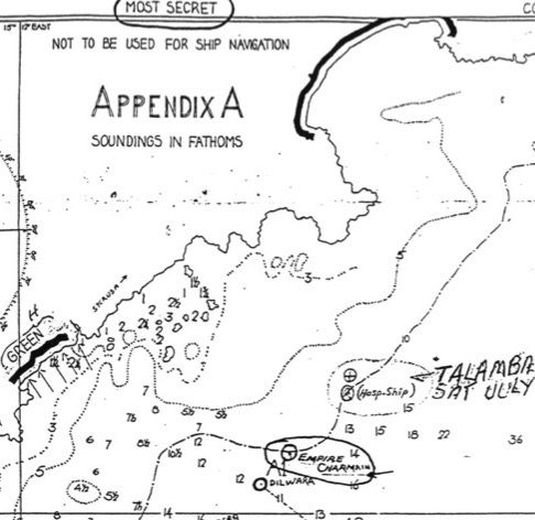
Thankfully (because a lot of beaches north of Avola will likely be soft and sandy!) I was able to track down more precisely where my father served with the 80th Flotilla. I located the following map, property of Bill Lindsay, 81st Flotilla, in one of my father's books re the Canadian role in Combined Operations. 

It is a treasure trove of fine details re particular ships, bays, beaches and coves,
and "soundings in fathoms" (if you are, say, a nautical person into fathoms).
Map or Appendix as found in St. Nazaire to Singapore Vol. 1, page 179

Whoever drew the map ("not to be used for ship navigation") has helped me find the exact location of GEORGE sector, a significant beach as far as I am concerned re my 'Dad's Navy Days.' As well, a great deal of information can be linked to some of the fine details on the map. Below I will just scratch the surface.

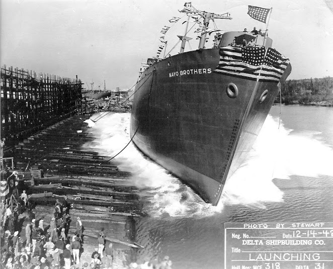
For example, a fathom is 6 feet (1.83m) in length, in this case depth. Flat-bottomed landing craft travelling in the direction of the arrows toward the beaches would only need very few feet of water in order to safely land ashore (and knowledge of the tides). But most craft larger than an LCA or LCM would require much deeper water to approach the shore. The dotted lines from left to right are numbered at 3, 5 and 10 fathoms and one will see much higher numbers off shore to the right. Six straight dotted lines may indicate where vessels were/could be stationed. E.g., At C1 is located Reina Del Pacifico (troop ship) for SNOL (Senior Naval Officer (Landing); at D3 is LST 368 (Landing Ship, Tanks); B3 is Mayo Brothers and C2 is Bigfoot Wallace (both U.S. Liberty ships), etc. 

Thanks to Mr. Google some information is available about the two Liberty ships just mentioned:

SS Mayo Brothers launching in New Orleans in December, 1942

[Mayo Brothers was launched by Delta Shipbuilding Co. in New Orleans. She represents the variety of fields and accomplishments of those for whom WWII Liberty ships were named. The SS Mayo Brothers was named for the brothers William and Charles Mayo, two of the founders of the group medical practice which would grow into the Mayo Clinic, devoted to patient care, research and medical education. The father of the Mayo boys and Civil War surgeon, William W. Mayo, would also have a Liberty ship named in his honor, the SS William W. Mayo, the following May. Post by Curator Kimberly Guise.]


Photo Credit for above two photographs - MARAD Vessel History

Other items on the map relate specifically to Canadians in Combined Operation and their flotillas of landing craft. For example, just north of A1 DILWARA (?) on the map one finds a notation re Empire Charmian (troop ship), and Talamba (Hospital Ship) "Sunk Sat. July 10/43."

My father had to be working nearby because in his memoirs he mentions taking wounded soldiers out to the Hospital Ship, and more. He writes: 

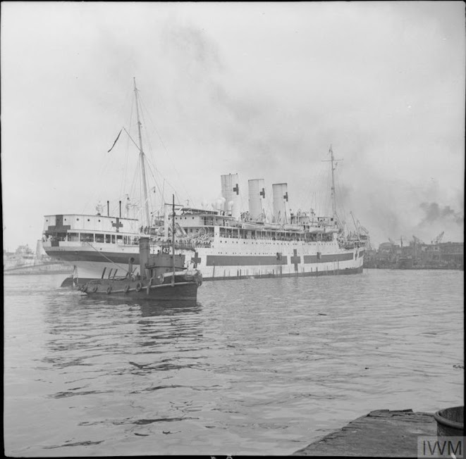
We had a hospital ship with us named the Alatambra (sic: Talamba) with many nurses and doctors aboard. She came in to about three miles in daytime and went out to seven miles and lighted up like a city at night. No one was to bomb a hospital ship and for many hours on end we took the wounded out to her, many being glider pilots with purple berets. Never a sound out of them, no matter how badly they were hurt. Mostly Scotch (sic: Scottish) soldiers.


HMHS Talamba. Sailing into harbour. 
Photo by Captain Ely, © IWM E 24034

My father continues:

One night we saw what appeared to be a tremendous bonfire in the east, offshore a long way out. In the morning, the Alatambra was gone (Lt. Cdr. Koyle says "the hospital ship (was) sunk at dusk on the 11th"), nursing sisters, doctors, wounded and all. Seven hundred and ninety were killed or drowned. The Germans had either bombed or torpedoed her that night. So goes war. ("Dad, Well Done", page 33)

My father's work sector was close enough to see the Talamba suffer fatal damage, so I think the bay in the top right corner of the enlarged map below (a piece of Bill Lindsay's map, aka "Appendix A"),  outlined in black (cf Green, Red and Amber beaches of HOW Sector, work area for the 81st Flotilla), is none other than GEORGE Sector, home of the 80th Flotilla for 4 weeks in July and early August.

Top right, GEORGE Sector, home of the 80th Flotilla, outlined in black
Note the shape of the "soft, sandy" bay and adjacent peninsula, directly south 

I think we have a perfect match of the exact area with a modern day Google map:


An enlarged Google map below reveals approximately the same amount of coast line as the larger Appendix A. Avola was mentioned by my father and it is about 10 km south of GEORGE Sector. (Avola and Noto were pencilled in, on Bill Lindsay's Appendix A, and I believe they are misplaced).


Using the distance guide (lower right with above map), the RED, AMBER and GREEN beaches of the 80th and 81st Flotillas stretch no more than 3 kilometres, and hiking trails are nearby. However, Avola is 7 km farther south, so I'll need to rent a bicycle or scooter while in Avola, southern Sicily to get to the area known as Fontane Bianche (GEORGE Sector). 

And what about the caves that members of the 80th Flotilla lived in for three weeks?

More to follow about Gord's trip to Sicily.

Please click here to view news articles from The Montreal Gazette - July, 1943 issues - about the Allied invasion of Sicily.

Unattributed Photos GH

Saturday, April 22, 2023

Photographs: The Miracle of Dunkirk (2)

Operation Dynamo, the Evacuation from Dunkirk

From Burning Oil Storage Tanks to a Cup of Tea

German photographs of British and French prisoners at Dunkirk, June 1940.
Photo - German official photographer, Imperial War Museum MH 2397

Introduction:

In the process of reading The Miracle of Dunkirk by Walter Lord I began searching for the odd, related photograph at the Imperial War Museum (IWM). Of course, with a deep archive of 11,000,000+ photos, the IWM did not disappoint. Yes, they had a few related pictures, maybe in the 100s - 1,000s.

Interested readers can visit and peruse IMW's deep files by using the following links -

The Dunkirk Evacuation, 27 May - 4 June 1940

https://www.iwm.org.uk/collections/item/object/205401212

Why the Dunkirk Evacuations were an unexpected success

https://www.iwm.org.uk/history/why-the-dunkirk-evacuations-were-an-unexpected-success

As well, please enjoy the following, all items attributed to the Imperial War Museum:

What you need to know about the Dunkirk evacuations,
26 May - 4 June 1940

1. It was a rescue mission

On 10 May 1940, Germany invaded France and the Low Countries, pushing the British Expeditionary Force (BEF), along with French and Belgian troops, back to the French port of Dunkirk. A huge rescue, Operation 'Dynamo', was organised by the Royal Navy to get the troops off the beaches and back to Britain.

A column of German MkIV and Czech-built 38(t)s tanks halted in valley
in escarpment on the far side of the Somme river after Rommel's force had
crossed the river, 26 May - 4 June 1940. Film exists of Rommel crossing a
small bridge and heading south to cross the Paris-Calais railway line proving
this photograph must have been taken after his force crossed the river.
Photo attributed to Field Marshal Erwin Rommel © IWM (RML 257)

[Link to more photographs related to Field Marshal Erwin Rommel]

2. The evacuation was code-named Operation Dynamo

Admiral Bertram Ramsay directed the evacuation. Ramsay had retired before the war but was recalled in 1939. He and his staff worked in a room deep in the Dover cliffs that had once contained a dynamo, a type of electrical generator, giving the operation its name.

A head and shoulders portrait shot of Admiral Sir Bertram Ramsay
who was in charge of the naval evacuation at Dunkirk. Photograph taken
at his London Headquarters in October 1943. By Lt. C. J. Ware, Royal
Navy Photographer. Imperial War Museum, © IWM (A 23440)

[Link to more photographs taken by Lt. C.J. Ware, Royal Navy Photographer]

3. The evacuation began on 26 May

'Dynamo' began on 26 May. Strong defences were established around Dunkirk, and the Royal Air Force sent all available aircraft to protect the evacuation. Over 800 naval vessels of all shapes and sizes helped to transport troops across the English Channel. The last British troops were evacuated on 3 June, with French forces covering their escape.

A Royal Navy destroyer, crowded with evacuated British troops,
mooring at Dover, 31 May 1940. © IWM H 1661

4. The 'Little Ships' helped

The gently shelving beaches meant that large warships could only pick up soldiers from the town's East Mole, a sea wall which extended into deep water, or send their boats on the beaches to collect them. To speed up the process, the British Admiralty appealed to the owners of small boats for help. These became known as the 'little ships’.

A view over a sea filled with vessels of different sizes. Fires burn on the
horizon filling the sky with clouds of thick grey smoke. There are several planes
above, trails of thick smoke, and explosions on the water amongst the boats.

5. Over 300,000 soldiers were rescued

Churchill and his advisers had expected that it would be possible to rescue only 20,000 to 30,000 men, but in all 338,000 troops were rescued from Dunkirk, a third of them French. Ninety thousand remained to be taken prisoner and the BEF left behind the bulk of its tanks and heavy guns. All resistance in Dunkirk ended at 9.30am on 4 June.

Object description Evacuated troops on a destroyer about to berth
at Dover, 31 May 1940. © IWM (H 1637)

6. The evacuation boosted morale

The Dunkirk evacuation was an important event for the Allies. If the BEF had been captured, it would have meant the loss of Britain's only trained troops and the collapse of the Allied cause. The successful evacuation was a great boost to civilian morale, and created the 'Dunkirk spirit' which helped Britain to fight on in the summer of 1940.

Object description Cheerful British troops in Britain after being evacuated
from Dunkirk, 1940. Two are wearing labels across their chests -
"Hitler's Grave Berlin" and "We demand Hitler Alive".

Other photos as found at the Imperial War Museum:

Original wartime caption: The arrival of Destroyers carrying troops
from Dunkirk. IWM H 1663

Original wartime caption: The arrival of Destroyers carrying troops
from Dunkirk. IWM H 1665

Original wartime caption: The arrival of Destroyers carrying troops
from Dunkirk. IWM H 1666

Original wartime caption: The arrival of Destroyers carrying troops
from Dunkirk. IWM H 1667

Original wartime caption: Stretcher cases leave the quayside.
IWM H 1669

Soldiers carrying a stretcher case along the quayside at Dover, 31 May 1940.
Note the crates of 'bully beef' and biscuits stacked behind. IWM H 1670 

Original wartime caption: A cup of tea for a wounded Tommy.
IWM H 1671

A group of 'walking wounded' British troops, in front of a railway carriage
at Dover, 31 May 1940. IWM H 1672

Original wartime caption: Tired and hungry troops get refreshments
from the Y.M.C.A. canteen on the quayside. IWM H 1673

A Hudson of RAF Coastal Command patrols over Dunkirk, as oil storage
tanks burn fiercely in the background, c. 3 June 1940. IWM C 1717

Original wartime caption: Part of the historic armada which
evacuated the B.E.F. from Dunkirk. IWM C 1719

Ships off the beaches at Dunkirk, c.3 June 1940. Smoke
billows from burning oil storage tanks. IWM C 1720
(Creator listed as RAF Official photographer)

[Click here for more photographers by RAF Official photographers

A Lockheed Hudson of No. 220 Squadron RAF approaches Dunkirk on a
reconnaissance patrol during the evacuation of the British Expeditionary Force
from the port in May - June 1940 (Operation DYNAMO). IWM C 1722

Aerial view of burning oil tanks at Dunkirk, June 1940.
Imperial War Museum, C 1723

The search engine at Imperial War Museum is a wonderful thing. I call it Search Dynamo!

Please link to Photographs: The Miracle of Dunkirk (1) for more authentic photos from Dunkirk, 1940.

Unattributed Photos GH

Wednesday, April 19, 2023

Photographs: The Miracle of Dunkirk (1)

Inspired by The Miracle of Dunkirk, by Walter Lord

Painting on the back of the book jacket on The Miracle of Dunkirk
Painting "The Little Ships at Dunkirk: June 1940" by N. Wilkinson

Introduction:

After reading The Miracle of Dunkirk recently and viewing, with interest, a good handful of black and white photographs from the actual event, I set out to find more related photographs. Using the search engine at the Imperial War Museum (IWM) in the United Kingdom, I soon had another good handful of B&Ws ready to share here. And at one point I stumbled upon a link to the art piece that adorns the book jacket that covers Walter Lord's significant book. 

Though some readers already easily breeze through the 11,000,000 million or more photographs archived at the IWM, I have provided a link or two that others may find useful. Happy hunting, I say.

Now, on to Dunkirk:

7 Photos from the Dunkirk Evacuations

With notes from IWM -

By the end of May 1940, Germany's rapid advance through north-west Europe had pushed the British Expeditionary Force (BEF), along with French and Belgian troops, back to the coast of the English Channel. Stranded on the beaches of the French port of Dunkirk, they faced certain capture, which would have meant the loss of Britain’s only trained troops and the collapse of the Allied cause. The Royal Navy hurriedly planned an emergency evacuation - Operation 'Dynamo' - to evacuate the troops and get them to Britain.

Over 338,000 soldiers, a third of them French, were rescued between 27 May and 4 June. The geography of the beach meant the Navy's large warships could either pick up soldiers from a sea wall that extended into deep water or send their boats onto the beach to collect them. To speed up the evacuation an appeal went out to owners of pleasure boats and other small craft for help. These became known as the ‘little ships’. The evacuation, hailed as miraculous by the press and public, was a big boost for British morale. But losses were still heavy and Churchill was cautious in his praise of the operation. He recognised that the great challenge was still to come.

Here are seven photographs from the evacuation of Dunkirk.


1. Waiting for rescue British troops line up on the beach
at Dunkirk to await evacuation. © IWM NYP68075 

2. Wading out to sea. British soldiers wade out to a waiting destroyer
off Dunkirk during Operation Dynamo. © IWM HU41240

3. The ‘little ships’ - Three of the armada of 'little ships' which brought
the men of the BEF from the shores in and around Dunkirk, to the
safety of British warships and other vessels. © IWM HU41241 

4. Returning Troops - British troops crowd the deck of a Royal
Navy destroyer at Dover, 31 May 1940. © IWM H1662

5. Arriving at Dover - A merchant sailor assists a wounded British soldier
up the gangplank from a destroyer, Dover, 31 May 1940. © IWM H1622

6. A much needed cup of tea - Evacuated troops enjoying tea and other refresh-
ments at Addison Road station, London, 31 May 1940. © IWM H1632

7. Temporary Safety - French troops evacuated from Dunkirk photographed
in a train at a railway station in the UK. HU104615 © IWM 

Here are a few more I found at London's IWM, under different 'Dunkirk' headings (there are several):

Aerial view of the beach at Dunkirk where some 300-400 men await evacuation.
Photo shows 700 yards of beach, about 4 miles east of the town. C1718 © IWM

Burning oil tanks at Dunkirk. C1721 © IWM

French and British troops on board ships berthing at Dover, 31 May 1940.
War Office official photographer (useful link) H1621 © IWM 

British troops on board a destroyer at Dover wait to leave the ship.

A British destroyer arrives at Dover carrying British troops from Dunkirk.
(Captain) A. Console, War Office official photographer. © IWM H1664

British troops disembark from a destroyer at Dover. 
(Captain) A. Console, War Office photogr. © IWM H1685

Facial portraits of four soldiers, wearing helmets, looking upwards.
By Edward Jeffrey Irving Ardizzone, IWM ART LD 135H, © IWM

A head and shoulder portrait of two soldiers, one with his arm around the
other, laughing. E. J. I. Ardizzone. IWM ART LD 135C © IWM Art

The aforementioned painted that I fortunately stumbled upon:

The Little Ships at Dunkirk: June 1940 by Norman Wilkinson

Details concerning the image: A view over a sea filled with vessels of different sizes. Fires burn on the horizon filling the sky with clouds of thick grey smoke. There are several planes above, trails of thick smoke, and explosions on the water amongst the boats. IWM ART LD 6007, © IWM Art.

There are many photographs online concerning the evacuation of British and French troops in late May to early June 1940. So, I may add another set of authentic photos and art pieces, when time allows.

Please click here to read a brief description of W. Lord's good book.

Please click here to view Photographs: Armada to Sicily, July 1943 (3)

Unattributed Photos GH