My Father Spent Three Months in the Mediterranean, 1943
I Will Visit 80 Yrs Later, to Recall Operations Husky & Baytown
D. Harrison stole chickens from a Sicilian cook in 1943, near Messina
When I fly over, I will pay back his debt! ("How much are 6 chickens?")
Introduction:
As a member of RCNVR and Combined Operations (1941 - 1945) my father drove Landing Craft Mechanised (LCMs) during Operation Husky (Allied invasion of Sicily) - beginning July 10, 1943 - and Operation Baytown (Allied invasion of Italy at the toe of the boot) - beginning September 3, 1943. [His memoirs re those Allied invasions can be found on this site.]
In a few months I will travel to Sicily and the toe of Italy's boot to walk in his faint footsteps, see some of the very same beaches, the lovely horizon of the Med, Sicilian towns and cities, visit (hopefully) the same cave he lived in for 3 weeks during Operation Husky (if I can find it; I think I can!), and buy a few chickens to pay off a long-standing debt (i.e., 80 years old!).
When I go I'll do what I did while in Scotland, England, Halifax and Vancouver Island a few years ago. Meet a few people who share an interest in WWII history, visit RCNVR and Combined Operations sites (related to training or service), hit a pub or two that my father hit many years earlier, "paint the town brown" (his words), check out related museums, libraries, archives, and be thankful I can travel to such places and meet such people.
In Sicily I will travel to Avola (south of Syracuse SE corner) for certain. The city is close to the area that four 'Flotillas of Canadian Landing Crafts' transported British troops and all the materials of war to beachheads in support of those troops. The following maps will help me find my way:
In Sicily I will travel to Avola (south of Syracuse SE corner) for certain. The city is close to the area that four 'Flotillas of Canadian Landing Crafts' transported British troops and all the materials of war to beachheads in support of those troops. The following maps will help me find my way:
Map re Allied landings as found in Combined Operations (a book re
the role of Canadians in Combined Ops) by Clayton Marks, London
Members of RCNVR/Comb.Ops like my father worked aboard landing
crafts on the east coast between Syracuse and Cape Passero. (Canadian
Army troops landed in southern Sicily, west of Cape Passero)
The map above puts my father, a member of the 80th Flotilla, somewhere near Avola. He mentioned the town or city in his memoirs but never mentioned the sector or beaches where he worked/served for four weeks.
Some of the members of the 80th Flotilla are listed upon a navy hammock.
Painter - S/Lt. Dave Rodgers. Hammock - W. N. Katanna, Leading Stoker.
Hammock as found at Navy Museum, HMCS Naden, Esquimalt B.C.
Though Dad never mentioned his location or sector (where delivery/unloading of supplies would take place) near Avola, his commanding officer provides important details in memoirs, as found in Combined Operations by Londoner Clayton Marks.
Lt. Cdr. J. E. Koyle (D.S.C., RCNVR) writes:
By 0730 all was quiet - terribly quiet. Everyone expected enemy aircraft from moment to moment and the anticipation intensified the stillness in spite of the intense activity, but it was not until 1130 that the first Italian fighter was seen flying low, hotly pursued by two Spitfires; and not until 1330 did a bombing attack develop. Then one bomber dropped a stick on the sector of "GEORGE" beaches worked by the 80th Flotilla, narrowly missing Lieut. Koyle who was on the beach at the time between an LCT and an LST which both suffered heavy casualties. Combined Operations, pg. 176 - 177
Thanks to Google and another paragraph or two from Lt. Cdr. Koyle about GEORGE, HOW and JIG Beaches - they were in close proximity, and the 80th and 81st worked closely together there - I poked around the internet and one day located the following map. GEORGE sector, north of HOW by about 1 - 2 miles, appears to be 5 - 6 mi. away from Avola. It also appears to be in a single location, not spread out along the coast in 3 locations like HOW.
Koyle stated the following as well:
For the first eighteen days of the operation, all craft of the 80th and 81st Flotilla were kept in operation all the time. This was a remarkable achievement and the more remarkable when it is considered that the beach conditions, especially in "GEORGE" sector, were not ideal. Although there were few rocks and sandbars offshore, the gradient of "GEORGE" beaches was very shallow, and both sectors had soft sandy beaches so that it was impossible to avoid sucking up sand into the pumping system when the craft were coming on and off the beach.
Combined Operations, pg. 176
Koyle not only kept his eye on both flotillas, he also had an eye for certain details. Now I know I'm looking for a curved bay with shallow gradient and "soft, sandy beaches. "
The 55th and 61st Canadian LCA* flotillas likely landed British troops in Bark
East zone, at NAN sector, at 3 designated beaches. The 80th and 81st flotillas
were made up of LCMs* and transported fuel, ammunition, food, lorries, jeeps...
(The Canadian Army landed in Bark West zone, at SUGAR and ROGER sectors.)
Map as found at Canadians at Arms (re Operation Husky)
*LCA - Landing Craft, Assault
*LCM - larger Landing Craft, Mechanised
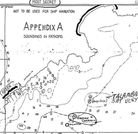
Thankfully (because a lot of beaches north of Avola will likely be soft and sandy!) I was able to track down more precisely where my father served with the 80th Flotilla. I located the following map, property of Bill Lindsay, 81st Flotilla, in one of my father's books re the Canadian role in Combined Operations.
It is a treasure trove of fine details re particular ships, bays, beaches and coves,
and "soundings in fathoms" (if you are, say, a nautical person into fathoms).
Map or Appendix as found in St. Nazaire to Singapore Vol. 1, page 179
Whoever drew the map ("not to be used for ship navigation") has helped me find the exact location of GEORGE sector, a significant beach as far as I am concerned re my 'Dad's Navy Days.' As well, a great deal of information can be linked to some of the fine details on the map. Below I will just scratch the surface.
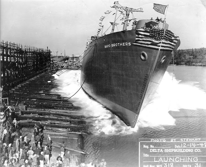
For example, a fathom is 6 feet (1.83m) in length, in this case depth. Flat-bottomed landing craft travelling in the direction of the arrows toward the beaches would only need very few feet of water in order to safely land ashore (and knowledge of the tides). But most craft larger than an LCA or LCM would require much deeper water to approach the shore. The dotted lines from left to right are numbered at 3, 5 and 10 fathoms and one will see much higher numbers off shore to the right. Six straight dotted lines may indicate where vessels were/could be stationed. E.g., At C1 is located Reina Del Pacifico (troop ship) for SNOL (Senior Naval Officer (Landing); at D3 is LST 368 (Landing Ship, Tanks); B3 is Mayo Brothers and C2 is Bigfoot Wallace (both U.S. Liberty ships), etc.
Thanks to Mr. Google some information is available about the two Liberty ships just mentioned:
SS Mayo Brothers launching in New Orleans in December, 1942
Photo Credit - The National WWII Museum, New Orleans
Photo Credit for above two photographs - MARAD Vessel History
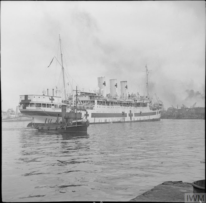
Other items on the map relate specifically to Canadians in Combined Operation and their flotillas of landing craft. For example, just north of A1 DILWARA (?) on the map one finds a notation re Empire Charmian (troop ship), and Talamba (Hospital Ship) "Sunk Sat. July 10/43."
My father had to be working nearby because in his memoirs he mentions taking wounded soldiers out to the Hospital Ship, and more. He writes:
My father continues:
One night we saw what appeared to be a tremendous bonfire in the east, offshore a long way out. In the morning, the Alatambra was gone (Lt. Cdr. Koyle says "the hospital ship (was) sunk at dusk on the 11th"), nursing sisters, doctors, wounded and all. Seven hundred and ninety were killed or drowned. The Germans had either bombed or torpedoed her that night. So goes war. ("Dad, Well Done", page 33)
My father's work sector was close enough to see the Talamba suffer fatal damage, so I think the bay in the top right corner of the enlarged map below (a piece of Bill Lindsay's map, aka "Appendix A"), outlined in black (cf Green, Red and Amber beaches of HOW Sector, work area for the 81st Flotilla), is none other than GEORGE Sector, home of the 80th Flotilla for 4 weeks in July and early August.
My father's work sector was close enough to see the Talamba suffer fatal damage, so I think the bay in the top right corner of the enlarged map below (a piece of Bill Lindsay's map, aka "Appendix A"), outlined in black (cf Green, Red and Amber beaches of HOW Sector, work area for the 81st Flotilla), is none other than GEORGE Sector, home of the 80th Flotilla for 4 weeks in July and early August.
Top right, GEORGE Sector, home of the 80th Flotilla, outlined in black
Note the shape of the "soft, sandy" bay and adjacent peninsula, directly south
I think we have a perfect match of the exact area with a modern day Google map:
Using the distance guide (lower right with above map), the RED, AMBER and GREEN beaches of the 80th and 81st Flotillas stretch no more than 3 kilometres, and hiking trails are nearby. However, Avola is 7 km farther south, so I'll need to rent a bicycle or scooter while in Avola, southern Sicily to get to the area known as Fontane Bianche (GEORGE Sector).
And what about the caves that members of the 80th Flotilla lived in for three weeks?
Please click here to view news articles from The Montreal Gazette - July, 1943 issues - about the Allied invasion of Sicily.
Unattributed Photos GH


No comments:
Post a Comment